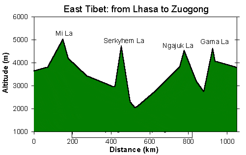
Yunnan Tibet Highway (Road 318/214): Lhasa to Zuogong
Yunnan Tibet Highway |
 ascend to Mi La pass near Rutok |
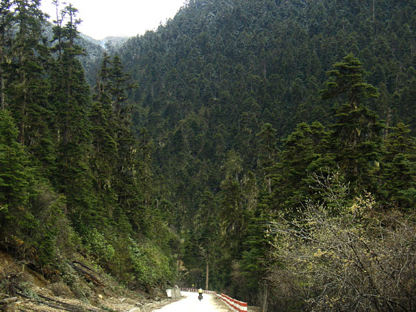 descend from Serkhyim La through Thuja forest |
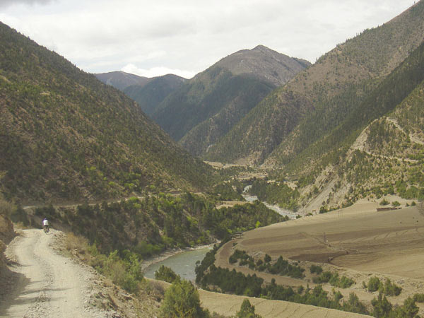 the small road along YuChu river |
The Yunnan-Tibet Highway (road 318) leads through spectacular landscape.
There are several high passes with long climbs from hot deserts to snow.
Large portions of the road are now paved, but the dirt road parts are still
challenging, especially during the rainy season. Be aware that significant
stretches of the dirt road in the Parlung Tsangpo valley are subject to
frequent landslides.
At Bamda, road 318 meets road 214, which follows the river Yu Chu. We took
road 214 from Lhasa to Zuogong, then we tried out a small track following
the Yu Chu river. For two-and-a-half days we cycled on this difficult track
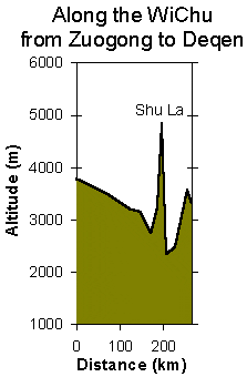
reaching the village BiTu. There it became clear that the road did not continue,
and that there would only be horse trails over the ShuLa pass to the Mekong
valley. Due to limited time, we could not go back and thus rode/pushed/carried
our bikes on the horse trails. Superb landscape on this stretch, but honestly
we do not recommend to do it with a bicycle...
Minor Road south along the Yu Chu River |
Distance Table and general information |
Something about checkpoints (May
2005): There are many traffic control checkpoints in Tibet.
Usually, at these checkpoints nobody cares about foreigners, as they are
run by the traffic police (dark green uniforms). Thus, almost every town
hase a barrier or some kind of checkpoint at the entrance to town. In East
Tibet we found all of the barriers to be open and if at all some offical
was present next to it, they did not care about us cycling through.
Likewise, military does not care about foreign cyclists as long as you don't
interfere with their business. Thus, military checkpoints are not to worry
about, and military truck convois are a f***ing pain because of the dust,
but nothing else.
We cycled through Bayi/Nyingchi at night - it was a recommendation given
to us by other cyclists we met in Lhasa (looking back I am not so sure anymore
if that would have been necessary). Apart from that, we stopped in all major
towns during the day to buy bread, but we never stayed in a hotel.
Our impression: It seems that officially
the region is opening up (you see a lot of English road signs etc.) and
nobody seems to be systematically looking out for foreigners. We met many,
many cyclists on road 318, also Chinese. However, local police may want
to earn bribes or fines and thus every now and then pick up on an easy victim.
By keeping a low profile, by being persistent and stubborn, and with a portion
of luck you'll be o.k.
Be aware that the situation can change any time
- be careful anyway.
| km marker | altitude (m) | description Yecheng (Xinjiang Province) to Domar (Tibet); Road 219 |
| 4635 | 3650 | from Lhasa, the paved road goes all the way to km marker 4147! |
| 4632 | Bridge over Kyi Chu | |
| 4572 | start of Gyalmashing valley | |
| 4563 | 3800 | town Meldro Gungkar |
| 4540 | village (shops) | |
| 4509 | village Rutok, hot springs; huge ugly hotel | |
| 4484 | 5013 | 'Mi La' pass |
| 4456 | truck stop | |
| 4403 | Tibetan village (shops etc.) | |
| 4360-4358 | 3420 | town Gongpo Gyamda |
| 4312 | town Namtse Zampa | |
| 4292 | village | |
| 4248 | military checkpoint with barrier | |
| 4235-4230 | 2976 | town Bayi, the road actually goes arond the town. No police station or barrier seen. |
| 4218 | military checkpoint with barrier | |
| 4214-4212 | 2960 | town Nyingchi, the road leads directily past the police station. |
| 4182 | 4565 | 'Serkhyim La' pass |
| 4156 | village Lunang; many restaurants | |
| 4147 | end of pavement | |
| 4135 | Tongyuk bridge | |
| 4114 | village Trulung | |
| 4110 | 2050 | Po Tsangpo; lowest point between Lhasa and Zuogong |
| 4098 | 2110 | Tangme |
| 4039 | pavement starts | |
| 4008-4006 | 2750 | town Bomi; good bakery in town! |
| 3931 | pavement ends, bad dirt road through Parlung Tsangpo gorge up to Rawok Co | |
| 3898 | pavement starts | |
| 3878 | 3840 | town Rawok |
| 3857 | 4530 | 'Ngajuk La' pass |
| 3793-3790 | 3200 | town Baxoi (Pasho) |
| 3765 | pavement ends;
dusty dirt road through desert landscape - there is no drinking water available between bottom of Gama La and Baxoi |
|
| 3754 | 2740 | Nakchu
Rampa bridge over Salween there is a small mountain stream for drinking water between bridge and bottom of Gama La |
| 3749 | start of climb to Gama La pass | |
| 3730 | small village with truckstop (water available!) | |
| 3712 | pavement starts | |
| 3709 | 4618 | 'Gama La' pass |
| 3696 | 4060 | town Bamda; road 318 meets road 214 |
| 3656 | town, bridge over Yu Chu | |
| 3632 | town Yarzhong | |
| 3590-3588 | 3800 | town Zuogong |
| 3584 | 3800 | turnoff for the small road along Yu Chu (Wi Chu) river; the track begins at a white chorten. From there, it is two-and-a-half days of riding on a challenging small track through the Yu Chu valley to BiTu. Hiking from there on. |
Other descriptions
of the Yunnan-Tibet Highway:
Route
descriptions Tibet Central and Tibet East (Fred Ferchaux)
Dali-Lhasa
(Janne Corax)
Stages of the West to East bike tour across Tibet:
Overview
Kashgar to Deqin - about 5000 km in 11 weeks. The tour leads from barren high plateau in the West to lush green forests in the East. More…
Fotos
Tibetan wild life
Xinjiang Tibet Highway
West Tibet / Chang Tang
Lhasa
Transhimalaya
Friendship
Highway
East Tibet
Kawa Karpo Region
Road Information
Xinjiang
Tibet Hwy (219)
Minor Roads West Tibet
Transhimalaya
Highway
Friendship
Highway
Yunnan Tibet (318/214)